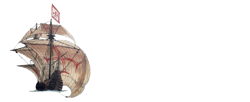
San Felipe, 1741
Jesús Alberto Aldana Mendoza
Country: Colombia
Place: Canal de Bocachica, Cartagena de Indias
Coordinates (approximate): Lat. ; Long.
Type: Ship of the line
Identified: Navío de Línea San Felipe
Dated: 1741
Introduction
During the English siege of Cartagena de Indias, during the War of Jenkins´ Ear (1739-1748), between March and May 1741, a large number of both English and Spanish vessels were shipwrecked in the middle of the war. The English fleet, led by the English Admiral Sir Edward Vernon, was composed of almost 200 ships intended to take this strategic port for the Caribbean. In contrast, the Spanish defense, led by Blas De Lezo and Sebastián De Eslava, had only six ships of the line, almost a dozen merchant ships and a couple of smaller vessels. The result was disastrous for both sides, however, the Spaniards achieved victory after several weeks resisting the English attacks that were forced to retreat due to a number of factors (including natural ones) that affected the entire fleet and its crew. Nevertheless, the consequences for the Spaniards were not few, not only a large number of the coastal fortifications that protected the city were destroyed, but also the small fleet of boats that protected the bay were all shipwrecked at different times during the battle. One of them was the Navío de Línea San Felipe, a ship that was sunk intentionally by the Spanish defenders to avoid the passage of the English ships by the Canal de Bocachica (south of the Isla de Tierrabomba), which was the only space of access to the bay of the port. In 2015 the remains of a colonial ship were found and excavations and historical approximations suggest that this shipwreck is possibly the San Felipe.
Team
Since the discovery of the material elements linked to a shipwreck in the Bocachica Canal, more than half a dozen archaeological interventions have been carried out in order to perform the interpretative analysis of the artifact remains resting on the seabed. To this end, the project has received the support of various national institutions such as the Instituto Colombiano de Antropología e Historia (ICANH), the Dirección General Marítima (DIMAR), the Centro de Estudios Oceanográficos e Hidrográficos (CIOH), the Armada Nacional de Colombia, the Instituto Nacional de Vías (INVIAS), the Escuela Taller de Cartagena de Indias (ETCAR), the Universidad Externado de Colombia and the Fundación Terrafirme, which formed an interdisciplinary working team. Likewise, national and international researchers from Argentina (Cristian Murray, Amaru Argüeso), Uruguay (Alejo Cordero), Mexico (Josué Guzmán), Spain (Carla Riera, Sergio López), Chile (Silvana Valls) and Colombia (Carlos Del Cairo, Ricardo Borrero, Lorena Palacio, Marcela Manrique) were present during the archaeological interventions. Also, in recent years the excavation of the boat has served to train new professionals in maritime and underwater archaeology from the Universidad Externado de Colombia.
Story of the Ship
Built in the Real Astillero de Guarnizo in the year 1726 under the direction of Lorenzo de Arzueta and the treaties of architecture and naval construction by Antonio de Gaztañeta e Iturribalzaga, the Navío San Felipe is a ship that carries between 80 and 84 guns on two decks and had a crew of about 600 sailors and soldiers on board. During its functional life it carried out different missions of the already established Real Armada Española in the Mediterranean, until in 1740 it set sail for the colonized Caribbean. Faced with the imminent attack by the English on Cartagena de Indias, the San Felipe made up the main line of defence, consisting of five other ships of the line (África, San Carlos, Galicia, Conquistador and Dragón) which had the mission of preventing the passage of the enemy fleet through the navigation channels of Bocachica and Manzanillo. These six ships were shipwrecked during the conflict, since by orders of Blas de Lezo they were intentionally sunk so that, as a last resort, they blocked the access of the external and internal bay. Purpose that finally they did not manage to fulfill.
Representation of the burning ship in historical cartography (Chaussereau, 1741)
Loss
The intensity of the English attack, initially towards the defences of the Canal de Bocachica, resulted not only in the destruction of the military fortifications located in this area (Baterías de Chamba, San Felipe y Santiago and the Castillo San Luis), but also in a drastic defensive tactic devised by Blas de Lezo to avoid, or at least delay, the English advance. This was the intentional sinking of the four ships that were arranged in the navigation channel (San Felipe, África, San Carlos and Galicia) and that were firing at the English fleet, the four ships had to be drilled to be partially submerged and the structures of the ships prevented the access of the enemy ships. However, in the middle of the hostile conditions only one was successfully drilled in the designed place (San Carlos), since the others, for different reasons, did not sink in the defined sector of the channel (África and San Felipe). This is different from what happened with the Galicia, which was taken by the English and used for siege. In the specific case of the Navío San Felipe, the initial objective was to drill it. Nonetheless, it was accidentally set on fire, causing it to move freely due to the action of the waves and the wind, until it stranded in the Bajo San José, finally sinking as the days went by without fulfilling the objective for which it was intended.
Find
In the archaeological diving trips during the dredging of the Canal de Bocachica in 2015, a series of wooden elements and another series of artifacts were identified at a depth of 5 meters that seemed to come from a large colonial boat (due to the characteristics of the elements). Since then, a series of interventions have been carried out to answer the different questions that arise around the shipwreck, so initially several studies were conducted to recognize the identity of the vessel. Archaeological and historical data collected suggest that possibly this vessel, which is located south of the navigation channel, near the Fuerte San Jose and the current Isla Draga, is the San Felipe Line Ship that dates back to 1741.
Approximate location of the ship (Google Earth)
Site Formation Process
Different factors of alteration, both anthropic and natural, have produced diverse effects on the archaeological context in which the shipwreck and its attached cultural elements are deposited. Among the natural factors are the oceanographic currents, the changing tides, the site’s fauna, the microorganisms present in the site and the action of the sun on the water temperature. The sum of all these factors, which are particular of tropical waters, has meant that the only elements that are preserved are linked to the lower section of the ship, which was deposited over the years under a layer of sediment that allowed it to be preserved unlike the rest of the ship’s hull. On the other hand, with respect to the anthropic factors, it is possible to find contemporary waste and rubbish, the nautical transit of the channel and the action of the waves produced by the boats and ships that travel it, the anchoring of boats, fishing, the sedimentation produced by the Canal del Dique formed from the Spanish Colony, the interventions on the sea bed (as is the case with dredging) and the historical extraction of materials.
Ballast
When the excavations were carried out in the study area where the structural elements of the ship were recorded, a large quantity of stones belonging to the ship’s ballast were found in the first layers. Until now it has not been possible to carry out a more precise characterization, typological classification or analysis. A large quantity of stones (river pebbles) of different shapes, sizes and origins have been found.
Shipwreck ballast (Aldana, 2019)
Ship Fittings
To date, it has not been possible to find any type of element linked to the equipment of the vessel, as no elements such as cannons or any type of debris linked to the vessel’s armament have been recorded, nor have any artefacts related to the vessel’s anchorage. This may surely be due to the historical recovery and recent extraction of materials from the site, leaving only those elements that have been historically covered by the sedimentation of this area and that have allowed its preservation.
Hull Remains
In relation to the elements linked to the hull of the boat, due to the natural alteration factors already mentioned, the only sections that have been preserved have been the structural parts such as the keel, the keelson, the bases of the frames, the internal and external hull planking, a “bularcama” and another set of woods that have not yet been identified.
3D reconstruction by photogrammetry of the internal hull planking of the ship (Aldana, 2019)
Fasteners
Different fastening elements, although not in a very good state of preservation, have been identified and recorded in the different excavations conducted to date. Firstly, there are the iron bolts linked to the elements of the main frame, which have been found attached to elements such as the keelson and the frames. Secondly, there are the iron nails that have also been identified in the strata related to the wooden elements that are still preserved on the seabed. Finally, there are the rods that have been recorded in relation to the lead sheets that go on the external hull planking of the ship to prevent the deterioration of the wood by the Teredo Navalis or “Broma”, as it is also known.
Iron nails of the ship (Aldana, 2019)
Cargo
The San Felipe is a ship which during its stay in Cartagena de Indias was destined entirely for the defense of the bay and its port, which is why in the archaeological record it is not expected to find any type of artifact related to the cargo of the ship, even more knowing that it was possible that this ship would be shipwrecked during the English siege before the immensity of the enemy fleet.
Personal Items
As with other elements of the ship, it is possible that the personal elements of the crew were recovered some time after the shipwreck, due to the shallow depth of the ship and the easy access to the elements that could still be rescued. Nevertheless, it was possible to identify a series of artifacts that were surely related to life on board the ship, such as different local and foreign ceramic remains, a couple of porcelain fragments, a few unidentified elements that could be hand tools and several pipes.
Ceramic fragments of the ship (Aldana, 2019)
Reconstruction
The approaches that have been formulated in relation to the architecture and construction of the possible San Felipe and the few elements that are still preserved (most of them in a poor state of conservation) have been developed from the shipbuilding treatise made in 1720 by Antonio de Gaztañeta e Iturribalzaga called “Proportions of the most essential measures for the manufacture of ships and frigates” where the main measures and constructive characteristics of different ships are indicated according to the amount of armaments they carried. In this case, for a ship of the line with 80 guns, the measurements recorded are:
Beam: Estimated 13.68 m. (24 codos)
Keel Length: Estimated 41.30 m. (72.5 codos)
Length Overall: Estimated 49.59 m. (87 codos)
Number of Masts: Three plus bowsprit.
Deliverables
Videos
https://video.nationalgeographic.com/video/news/00000150-b003-dd38-ab58-ff0796280000
https://www.youtube.com/watch?v=amh4b-Ezl5w&feature=youtu.be
https://www.youtube.com/watch?v=Z8r00pQXou8&t=3s
References
Aldana, J. (2019). Propuesta metodológica para la construcción de una matriz de indicadores arqueológicos e históricos para la identificación de naufragios: El caso de un navío colonial ubicado en el canal de Bocachica (Cartagena de Indias). Universidad Externado de Colombia.
Del Cairo, C. (2013). Entre naves y fuertes: Arqueología de las batallas costeras de 1697 y 1741 en Bocachica. Isla de Tierrabomba, Cartagena de Indias. Instituto Colombiano de Antropología e Historia (ICANH).
Del Cairo, C. & Palacio, L. (2014). Prospección arqueológica y Plan de Manejo Arqueológico para la modificación de la licencia ambiental para el dragado de profundización del canal de acceso a la Bahía de Cartagena de Indias, Colombia. Aqua & Terra Consultores Asociados – Instituto Nacional de Vías (INVIAS).
Fundación Terrafirme (2015). Investigación arqueológica y de las medidas de protección, intervención y divulgación de un pecio colonial localizado en espacios subacuáticos en la zona de Bocachica, Cartagena de Indias. Informe 1. Instituto Colombiano de Antropología e Historia (ICANH).
Fundación Terrafirme (2017). Investigación arqueológica y de las medidas de protección, intervención y divulgación de un pecio colonial localizado en espacios subacuáticos en la zona de Bocachica, Cartagena de Indias. Instituto Colombiano de Antropología e Historia (ICANH) – Instituto Nacional de Vías (INVIAS).
Riera, C. (2019). Aprender Haciendo: La conservación del material arqueológico subacuático procedente de un naufragio en Cartagena de Indias. Museos: Entre la historia y los patrimonios. Asociación Colombiana de Estudios del Caribe (ACOLEC).
Romero, L. & Pérez, J. (2005). Naufragios y puertos marítimos en el Caribe colombiano. Siglo XXI editores.