Arqueología del Paisaje de la Guerra y el Espacio Náutico en Cartagena de Indias / Archaeology of the War Landscape and the Nautical Space in Cartagena de Indias in 1697-1741
Autores del Proyecto e Instituciones Vinculadas / Project Authors and Related Institutions
Carlos Del Cairo Hurtado
(https://independent.academia.edu/CarlosDelCairo)
Carla Riera Andreu
(https://independent.academia.edu/CarlaRieraAndreu)
Victoria Báez Santos
(https://uexternado.academia.edu/LauraBaez)
Jesús Alberto Aldana Mendoza
(https://uexternado.academia.edu/Jes%C3%BAsAlbertoAldanaMendoza)
Instituciones / Institutions: Dirección General Marítima (DIMAR), Universidad Externado de Colombia.
Resumen del Estudio / Study Summary
Las diversas aproximaciones investigativas que se han desarrollado en la Bahía de Cartagena de Indias han permitido entender esta región como un escenario que está compuesto por gran cantidad de campos de batalla, a causa del asedio de las diferentes invasiones europeas como es el caso de Inglaterra y Francia. En el medio de todas estas confrontaciones, las embarcaciones han tenido un rol fundamental. El objetivo de los nuevos estudios consiste, ahora, en analizar desde una escala mayor la trayectoria histórica militar y bélica de la ciudad a partir de los diferentes elementos que configuran un Paisaje de la Guerra. En este conjugan una gran cantidad de elementos arqueológicos, muebles e inmuebles, que tienen la capacidad de aportar información vital para entender este territorio y su vínculo directo con las comunidades humanas que lo habitaban.
Uno de los principales protagonistas de este paisaje es el Espacio Náutico, ya que las condiciones geográficas y geomorfológicas de la Bahía de Cartagena de Indias producen que los medios de acceso a ella sean, en su mayoría, por espacios marítimos. Es aquí donde las embarcaciones adquieren un rol determinante en las dinámicas que han definido la historia de la ciudad, debido a que son los elementos que conectan a las personas entre puertos y, por ende, actúan como ejes fundamentales en la economía de las sociedades globales. En el caso de Cartagena de Indias, es posible identificar tres áreas de intensidad de confrontación bélica en donde las rutas de acceso han determinado un enorme potencial arqueológico en materia náutica: el Canal de Bocachica, el Canal de Manzanillo y el Acceso de Bocagrande. Diferentes fuentes de información señalan que en estas tres áreas se han presentado gran cantidad de eventos que han dado lugar a contextos arqueológicos que pueden ayudar a analizar este Paisaje de la Guerra y, al mismo tiempo, caracterizar sus Espacios Náuticos. En este orden de ideas, la presente investigación pretende analizar integralmente el Paisaje de la Guerra de la ciudad vinculado a la contienda de 1741 y sus correspondientes elementos culturales que pueden estar depositados en contextos terrestres, costeros y sumergidos.
***
The various investigative approaches that have been developed in the Bay of Cartagena de Indias have allowed us to understand this region as a scenario that is composed of a large number of battlefields, due to the siege of the different European invasions such as England and France. In the middle of all these confrontations, boats have played a fundamental role. The aim of the new studies is now to analyze the city’s military and warlike history on a larger scale, starting from the different elements which configure a Landscape of War. In this, a large number of archaeological elements, furniture and buildings, which have the ability to provide vital information to understand this territory and its direct link with the human communities that inhabited it, conjugate.
One of the main protagonists of this landscape is the Nautical Space, since the geographical and geomorphological conditions of the Bay of Cartagena de Indias produce that the means of access to it are, for the most part, by maritime spaces. It is here that boats acquire a determining role in the dynamics that have defined the history of the city, because they are the elements that connect people between ports and, therefore, act as fundamental axes in the economy of global societies. In the case of Cartagena de Indias, it is possible to identify three areas of intensity of warlike confrontation where the access routes have determined an enormous archaeological potential in nautical matters: the Canal de Bocachica, the Canal de Manzanillo and the Acceso de Bocagrande. Different sources of information indicate that a large number of events have been presented that have generate archaeological contexts that can help to analyze this War Landscape and, at the same time, characterize its Nautical Spaces. In this order of ideas, this research aims to comprehensively analyze the War Landscape of the city linked to the 1741 conflict and its corresponding cultural elements that may be deposited in terrestrial, coastal and submerged contexts.
Objetivos de la Investigación / Research objectives
General / General
- Analizar los componentes del Paisaje de la Guerra vinculados a la batalla de 1741 y sus correspondientes Espacios Náuticos en contextos terrestres, costeros y sumergidos de Cartagena de Indias.
- Analyze the components of the War Landscape linked to the battle of 1741 and their corresponding Nautical Spaces in terrestrial, coastal and submerged contexts.
Específicos / Specifics
- Caracterizar las áreas donde se presentó mayor confrontación bélica en la Bahía y los elementos arqueológicos que las componen.
- Recopilar diversas fuentes de información históricas y arqueológicas que permitan examinar con un mayor detalle la confrontación militar entre ingleses y españoles en 1741.
- Rastrear el desarrollo de la batalla en el paisaje y los espacios en los que sucedió a partir de los datos recuperados en las fuentes de información consultadas.
- Characterize the areas where the greatest warlike confrontation occurred in the Bay and the archaeological elements that compose them.
- Compile various sources of historical and archaeological information that allow examining in greater detail the military confrontation between English and Spanish in 1741.
- Track the development of the battle in the landscape and the spaces in which it happened from the data retrieved from the sources of information consulted.
Resultados Obtenidos y Perspectivas a Futuro / Results Obtained and Future Prospects
El presente proyecto se trata de una investigación que aún se encuentra en sus primeras fases de estudio, en donde se sigue recopilando información vinculada al Paisaje de la Guerra y los Espacios Náuticos de Cartagena de Indias y su confrontación de 1741, enmarcada en la Guerra de Asiento. Las diferentes aproximaciones investigativas (desde perspectivas tanto arqueológicas como históricas) que se han realizado hasta la fecha en la bahía para caracterizar contextos terrestres, costeros y subacuáticos vinculados a los campos de batalla, permiten estructurar las bases teóricas y conceptuales que definen este proyecto arqueológico. Los hallazgos documentados, los datos obtenidos y los análisis planteados generaron un banco de datos considerable que puede ayudar a entender la configuración de este Paisaje de la Guerra y, en definitiva, cómo actuó en el marco de una contienda tan grande como la que enfrentó a las tropas de Sir Edward Vernon con las de Don Blas de Lezo.
De esta manera, el propósito ahora radica en analizar con mayor detalle nuevos contextos arqueológicos vinculados a la batalla de 1741 en las áreas de estudio definidas: el Canal de Bocachica, el Canal de Manzanillo y el Acceso de Bocagrande. Aunque, así mismo, se pretende seguir abordando los yacimientos históricos ya intervenidos que aún tienen mucha información por brindar y que, en conjunto con los demás elementos y desde una perspectiva integral, pueden contribuir enormemente a entender la trayectoria histórica de Cartagena de Indias y su rol militar tan estratégico para defender los intereses de la Corona Española.
***
This project is an investigation that is still in its early stages of study, where information is still being collected in relation to the War Landscape and the Nautical Spaces of Cartagena de Indias and their confrontation of 1741, framed in the Guerra de Asiento. The different investigative approaches (from both archaeological and historical perspectives) that have been carried out until now in the bay to characterize terrestrial, coastal and underwater contexts linked to battlefields, allow structuring the theoretical and conceptual bases that define this archaeological project. The documented findings, the data obtained and the analyzes performed generated a considerable database that can help to understand the configuration of this Landscape of War and, ultimately, how acted in the framework of a campaign as large as the one that faced Sir Edward Vernon’s troops with Don Blas de Lezo’s.
In this way, the purpose now lies in analyzing in greater detail new archaeological contexts linked to the battle of 1741 in the defined study areas the Canal de Bocachica, the Canal de Manzanillo and the Acceso de Bocagrande. Although, likewise, it is intended to continue approaching the historical sites already intervened that still have a lot of information to provide and that, together with the other elements and from an integral perspective, can greatly contribute to understanding the historical trajectory of Cartagena de Indias and its strategic military role to defend the interests of the Spanish Crown.
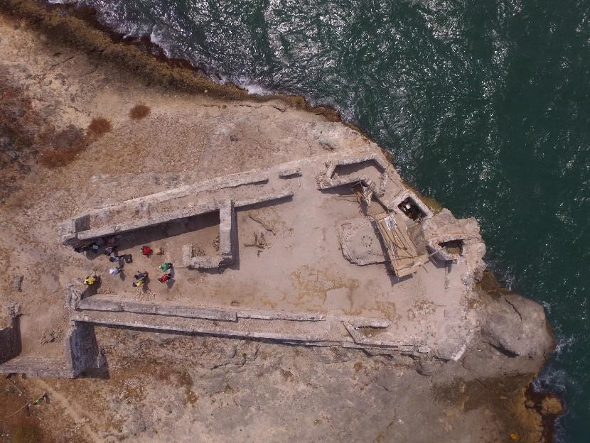
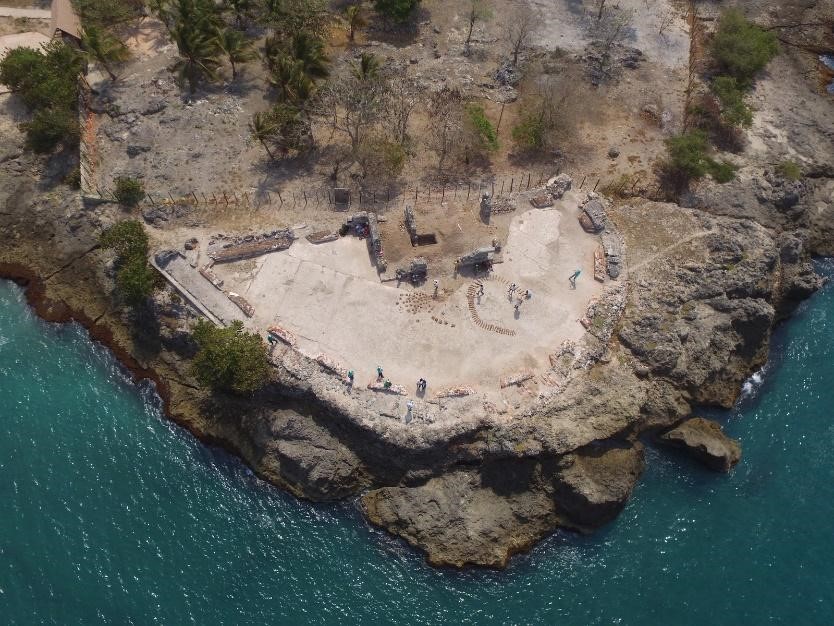
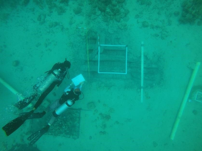
Galería fotográfica / Gallery
Restos estructurales de baterías militares y embarcaciones intervenidas en investigaciones arqueológicas que conforman el Paisaje de la Guerra y el Espacio Náutico de Cartagena de Indias / Structural remains of military batteries and ships intervened in archaeological investigations which compose the War Landscape and the Nautical Space of Cartagena de Indias (Tomadas por / Taken by Carlos Del Cairo & Carla Riera):